 |
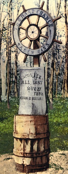
The card says, "Memorial, erected at Old Field, Setauket, L. I." On the memorial the ships wheel reads "The Hard Chance; Saeem [Salem?] Mass." and below "Captain Weeks; All Lost; Nov 27, 1898 Ashore in Blizzard." I can not find any reference to a ship called Hard Chance. This memorial was on the property that later belonged to Ward Melville. The card was published by The Long Island News Company, Flushing, and mailed in 1907, but was printed before that. |


